


You might be interested
Australia’s devastating bushfire season has made us more aware of the weather conditions involved in sparking, spreading and suppressing bushfires.
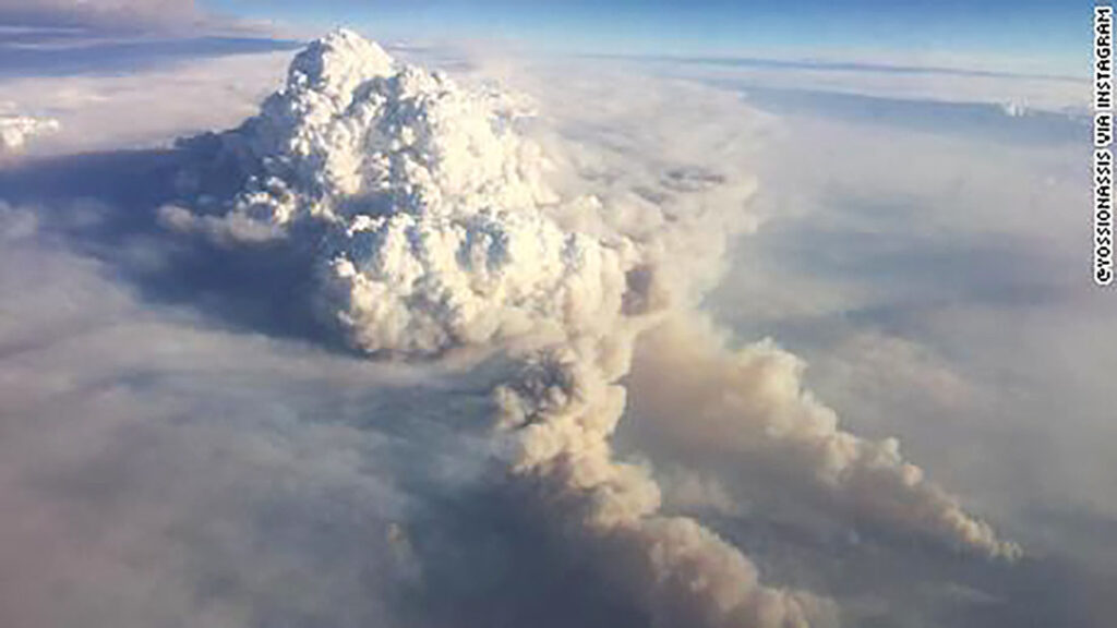
As the fires have grown in ferocity, we’ve seen an incredible phenomenon – the formation of ‘pyrocumulonimbus’ clouds and storms. We’re dealing with fires powerful enough to create their own weather systems.
It starts with large, intense smoke plumes. From there, a pyrocumulonimbus system can wreak havoc by throwing huge ‘downbursts’ of air onto the ground, carrying burning embers downwind that ignite new fires, or sparking new fires by lightning strike.
So what do we know about these systems and how can firies fight fires of this intensity in the future?
A perfect firestorm
Many ingredients need to come together for a pyroCb event to develop, says Dr Kevin Tory, Senior Research Scientist from the Bureau of Meteorology and Bushfire and Natural Hazards Cooperative Research Centre.
“First, there needs to be massive amounts of heat,” says Kevin.
Ultimately, the fire needs to be powerful enough to produce a large and vigorous smoke plume that rises perhaps 3km to 5km before cloud can form in the smoke plume. Then only if the smoke plume still has abundant energy at this height will a thunderstorm form.
“The perfect weather conditions for generating an intense fire are hot, dry and windy. If you get this combination with plenty of dry fuel, a fire will burn like crazy.”
However, hot and dry means the smoke plume is also dry, since most of the air in the smoke plume was mixed in from outside. This means the smoke plume has to rise even higher before cloud can form.
And if it’s windy, the smoke plume gets blown over, making it even harder for it to rise high enough for cloud to form.
In contrast, the perfect conditions for creating a plume are warm, moist and very light or no wind.
“so…It needs to be hot, dry and windy enough to get intense fires; but not too hot and dry that your plume has to grow really tall and not too windy that your plume gets blown over,” Kevin explains.
Blowing in the wind
A wind change is a common way this ideal mix of conditions comes about.
Hot, dry and windy conditions might generate a very large and intense fire, while being too hot, dry and windy for pyroCb to develop.
If a sea breeze or cold front was to arrive at the fire with a change in wind direction, the fire can get even larger and hotter when the long fire ‘flanks’ become active ‘head’ fires.
But perhaps the most important change is in the new air mass itself. The cooler and moister air allows cloud to form in the smoke plume at much lower levels.
Furthermore, says Kevin, “when the two air masses come together like this… it creates a moment where there’s zero wind, or very light winds, and this allows the plume to stand up really tall.”
Putting this all together, the change in wind direction produces a larger and hotter fire with a much more vigorous plume, the reduced wind speed allows the plume to grow taller and the cooler and moister air drawn into the plume allows cloud to form at lower elevations.
Heating up the Briggs equations
For the past four years, Kevin has researched these cloud systems to better understand the dynamics of basic plume rise. He’s building on research from almost 70 years ago.
“In the 50s and 60s there was widespread interest in understanding how plumes rise from smoke stacks because there were serious air quality issues in cities all around the world,” says Kevin.
Engineers wanted to see how tall smoke stacks needed to be to ensure the air downwind was clean. Without computers, they found simple solutions based on observations, but their equations were often inaccurate.
However, the Briggs Equations based on complex fluid dynamics (first published in 1975) were surprisingly simple and accurate and ideal for the pyroCb problem.
A simple calculation
Aiming to keep it simple, Kevin is measuring the total heat flux going into a smoke plume.
“The fire community talks about fire power. This is basically the rate at which energy, in the form of the heat, enters the plume or flows up through the plume,” says Kevin.
“What we’re doing is calculating the minimum fire power required for pyroCb to form.
“We call this the pyrocumulonimbus firepower threshold (PFT), and it can basically be reduced to a function of three variables.”
The first is the height the plume must rise to before the cloud will form with enough energy to generate a thunderstorm – the free-convection height (Z).
The second is the average wind in the layer below that free-convection height – the mixed layer wind speed (U).
The third is the temperature increment. This is how much warmer the smoke plume needs to be than the air in the mixed layer (∇T).
It looks like this:
PFT=0.3×(Z^2 )×U×∇T
The value produced is in gigawatts when Z is entered in kilometres, U is in metres per second and ∇T is in ℃. It is a theoretical minimum amount of energy a fire needs to produce for a pyroCb to develop.
Fighting fires with equations?
Kevin acknowledges that each fire is unique.
“However, if we produce the forecast map of the PFT hourly…you can see these patches or regions of low value – which equals high threat – moving throughout the landscape.”
Forecasters can use these maps to identify risk areas.
“They can see that they might have a problem at 4pm at a certain fire because there’s a wind change coming through. If there’s a quite low value of PFT on that wind change, we need to watch out for it,” Kevin says.
Iron in the fire
Over the next 6 months, Kevin will apply the PFT to weather data from the last 30 years to see if weather conditions are changing to make pyroCb conditions more favourable.
“Only a few years ago, pyroCb events were extremely rare,” Kevin says. “Last year, we had 15 in Eastern Victoria between January and March. And this has been completely surpassed by the numbers we have seen in southeast Australia since October.”
For researchers, it’s an opportunity to investigate how and why it’s happening more often.
For firefighters, understanding the unpredictability of fires when these systems develop is critical.
“It continues to amaze me that these fires can produce the truly enormous amount of energy needed to generate a pyrocumulonimbus cloud,” says Kevin. “The potential for destruction is huge.”

Interested in learning more about fire and its impact on the people and environment of Western Australia? Tune into the second season of the Elements podcast.
Across five episodes, we cover everything from festival bonfires to devastating wildfires, from echoes of ancient knowledge to the technological possibilities of the future. It’s going to be lit🔥
All episodes out now on all your favourite podcast platforms.

