


You might be interested
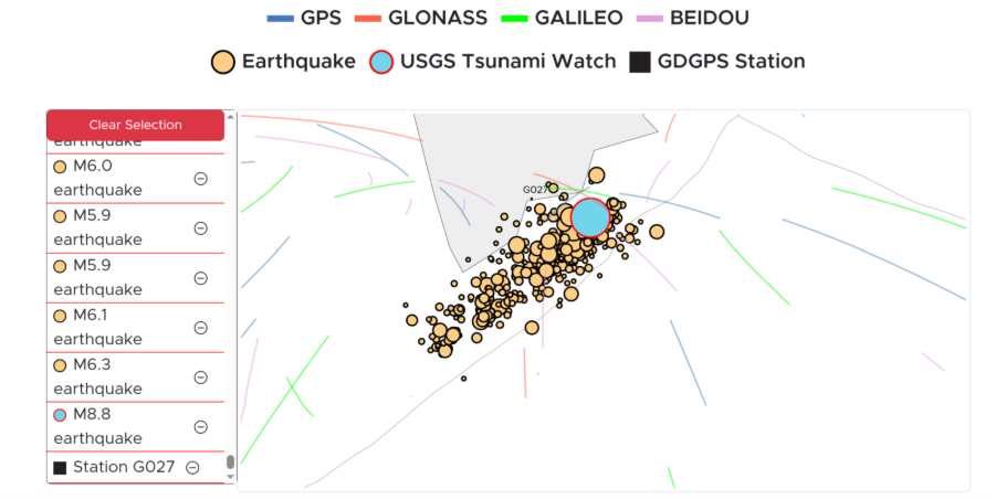
On 30 July, a magnitude 8.8 earthquake off Russia’s Kamchatka Peninsula triggered a tsunami that spread across the Pacific Ocean.
In addition to warnings from seismic centres and deep ocean pressure sensors, scientists had an early warning from a surprising place: the upper atmosphere.
It turns out that Global Positioning System (GPS) error correction – the thing that helps your car know where to go – can help detect tsunamis.
SENDING SIGNALS
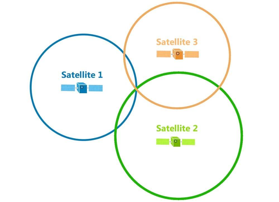
GPS works by measuring how long it takes for a signal to travel between a receiver, say your phone, to several GPS satellites in space.
These signals travel at the speed of light, which is constant. This means that your receiver can calculate how far away the satellites are, if it knows how long it took the signal to reach you.
Once your phone knows how far away you are from multiple GPS satellites, it can work out where it is. This process is called trilateration.
Credit: GIS Geography
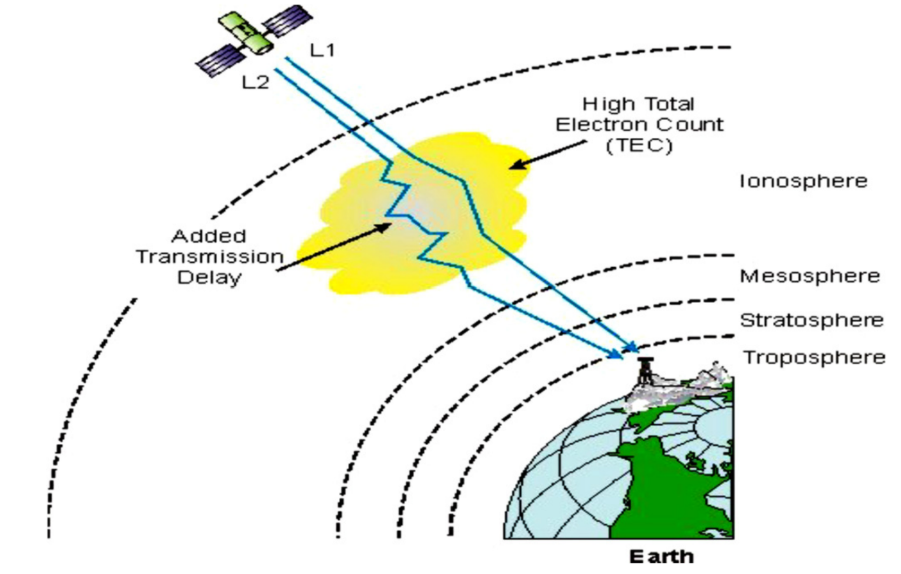
Unfortunately, GPS signals are affected by the upper atmosphere – the ionosphere. The ionosphere contains many free electrons moving around as a plasma.
Radio signals between GPS receivers on the ground and satellites in space interact with the free electrons, slowing them down and taking longer to reach your phone.
Since light travels so fast, a delay of just a few milliseconds can add up to an error of many metres in accuracy.
ELECTRONS RIDE THE WAVE
For this reason, GPS operators spend a lot of effort studying the ionosphere and monitoring its activity, ultimately trying to estimate the Total Electron Count.
Once you can estimate this, your GPS receiver can subtract off the delay to correct for errors introduced by the ionosphere.
Credit: Abba Et al
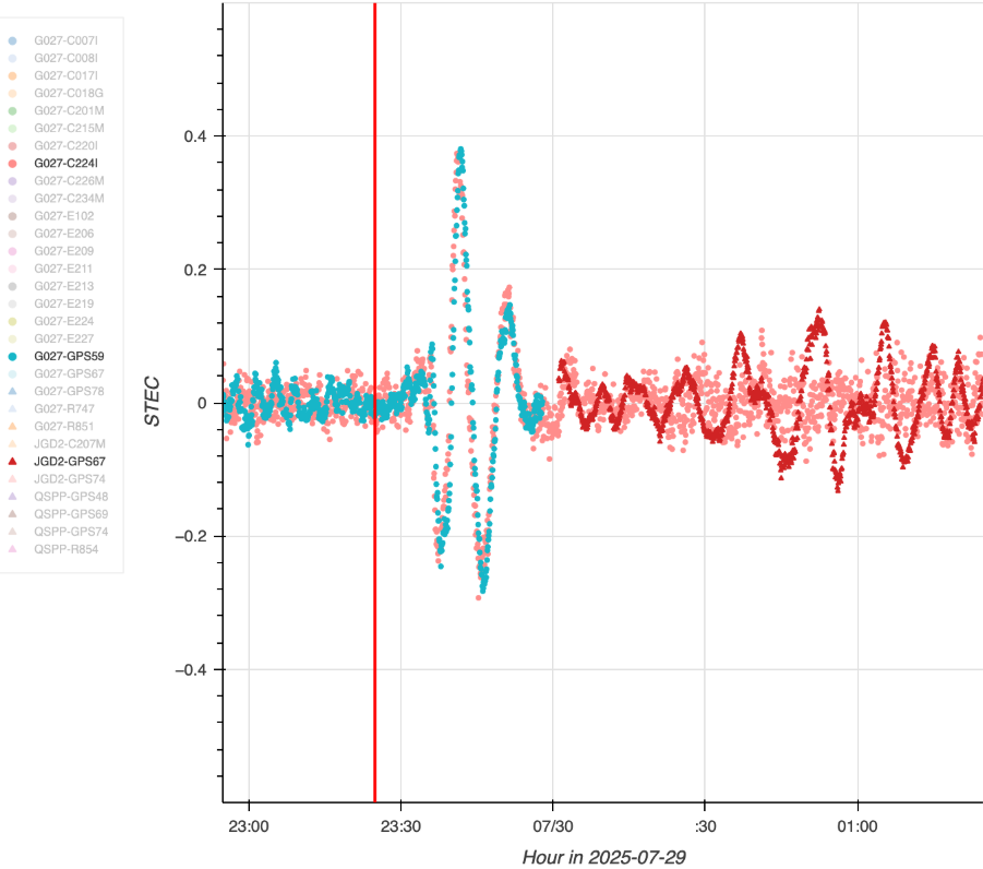
The ionosphere is highly variable, affected by solar activities, day and night cycles, and the general motion of the atmosphere itself.
During a tsunami, a huge area of the ocean’s surface rises and falls in a single motion, which pushes a substantial amount of air above it.
These ripples in the atmosphere rise all the way to space where they cause ripples in the ionosphere, which can then be detected by global navigation devices.
Credit: Credit: NASA/JPL-Caltech
ONE DAY’S NOTICE
This is where NASA’s GUARDIAN technology enters the story.
Like all NASA projects, it’s a tortured acronym. GUARDIAN stands for GNSS Upper Atmospheric Real-time Disaster Information and Alert Network.
GNSS stands for Global Navigation Satellite System, of which GPS is an example.
On 29 July, researchers had just installed an automated system for GUARDIAN. It would constantly check ionosphere data, and would send a notification to scientists if something interesting happened.
The very next day it detected ripples in the ionosphere caused by the Kamchatka earthquake less than 20 minutes after it occurred.
This allowed a 40 minute warning before the tsunami reached populated areas of the Pacific.
Credit: NASA/JPL-Caltech
SPACE TECH ON EARTH
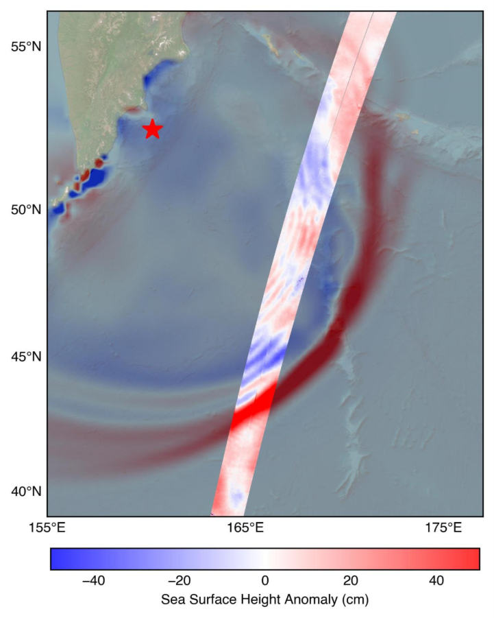
Meanwhile, the US-French SWOT (Surface Water and Ocean Topography) satellite passed overhead while the tsunami was travelling.
Amongst other things, SWOT measures the height of the ocean surface relative to its average and clearly detected the presence of the tsunami. It provided valuable confirmation and feedback to oceanographic models of these waves.
Credit: NASA/JPL-Caltech
This incredible case study shows how space technology has applications much closer to the ground than you might think.
