

You might be interested

Deep below the surface of Murujuga, soil expands and contracts from the passage of water. Each wetting cycle is like a sodden breath from lungs holding fragments of stone and shell.
Stone artefacts from millennia of Aboriginal life are pushed up slowly, maybe only a few millimetres each decade. In one final gasp, they break the surface.
A thousand-year-old knife lying on the surface, as if dropped yesterday.
For the scientists and Elders trying to preserve the past, this slow grinding over centuries confuses archaeological records.
Murujuga’s moving earth
Upon this rich and red landscape, the Ngarli-Ngarli peoples have carved up to 2 million petroglyphs into the rock faces over the last 50,000 years.
But Professor Matthias Leopold and his colleagues weren’t looking at the petroglyphs – they were searching for buried fragments of Aboriginal life over millennia.
Alongside the Murujuga Aboriginal Corporation, the scientists wanted to carefully drill into the earth to peel back centuries of layered clay and sand – all to learn the story of life on Middle Gidley Island.
Middle Gidley Island is part of Murujuga, sitting off the coast of the Burrup Peninsula. At the island’s centre is a single, large sediment basin.
Credit: Mather et al., 2025/Archaeometry
“Think of it like a massive bowl, where different layers of sediment are nicely stacked one over the other,” says Matthias.
“That’s why we wanted to drill, to find evidence of older environmental layers. We drilled down 10 metres but the core didn’t show the nice layering we were expecting,” he says.
“That was when we really started thinking about the processes that could influence the distribution of artefacts.”
Clues from the past
Fragments of ancient stone and shell were found exposed across the basin. Each tool fragment discovery was marked with a small square.
In one square lay stone flakes and shellfish remains, while another held the remains of an axe or grindstone.
Back in the lab, carbon dating revealed that hundreds of these artefacts came from different eras.
This research helps demonstrate this landscape’s importance, which was added to UNESCO heritage listing in 2025.
Credit: Mather et al., 2025/Archaeometry
The sediment basin on Middle Gidley Island is a mixture of stone, sand and clay. Each soil type acts differently when wet.
To an archaeologist like Professor Jo McDonald, this was evidence of an old trick that Australia’s claypans like to play on archaeologists.
The hard surfaces of claypans hold the history of how Aboriginal desert peoples used the known nearby water sources.
“We’ve been interested in what makes these amazing concentrations of artefacts,” says Jo.
“The analysis we have done shows that, in claypans – unlike sand dunes – all the artefacts don’t just sink below the surface. They appear to just sit there on the surface.”
The earth’s constant shifting confused this record, making it impossible to arrive at relative ages for the found artefacts.
Jo says the team had agreed not to remove any of the stone artefacts as they did analysis on the soil and rock.
Scanning the soil’s secrets
Containers of sand, clay and soil from Murujuga were carefully transported back to Perth for analysis.
Dr Caroline Mather took 4 kg of island topsoil to her geochemistry lab. The archaeologists created experimental copies of the artefacts from a similar igneous stone.
Over 6 weeks they wet and dried the soil to simulate the island’s seasonal rain events.
It must have been a strange sight at Harry Perkins Institute of Medical Research, with Caroline and her honours student Kaitlin Sullivan wheeling tubs of soil through the corridors.
“There was a bit of intrigue, that’s for sure,” says Caroline. But they needed a CT scanner to peer through the soil layers.
“You’d go into this room and other people would be dissecting mice. I think they were a bit confused that we were very carefully wheeling in many tubs of soil,” she laughs.
The CT scanner was used to track the buried artefacts moving over weeks. From this, Caroline could calculate how they might move over hundreds or thousands of years.
The scan showed artefacts buried in sand were pulled deeper over time, while the clay would slowly push the tools upwards.
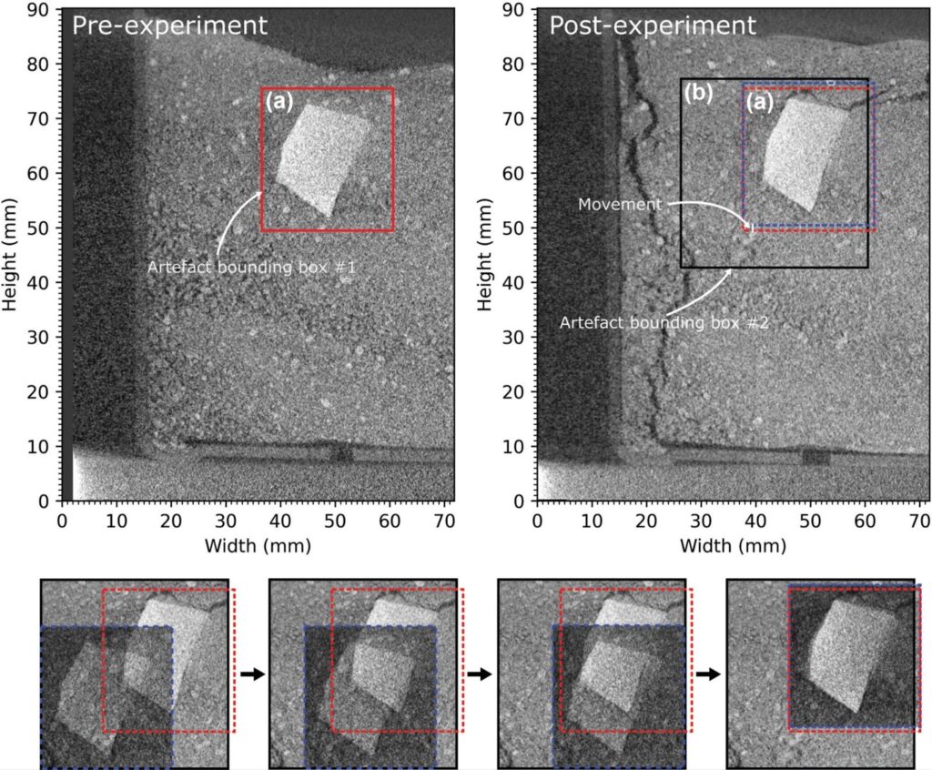
Credit: Mather et al., 2025/Archaeometry
Using Murujuga as a case study, Matthias, Jo and Caroline were able to show how the moving earth can complicate our understanding of Australia’s history.
Imaging, drilling and records show Murujuga’s soil is not a static tomb for the past but a shifting, breathing story where ancient history may rise again.